Storm Eunice Bristol: when will strong winds and rain hit, how long will it last - weather warning explained
and live on Freeview channel 276
Storm Dudley is set to make way for Storm Eunice as the Met Office issues a red and amber ‘danger to life’ warning for parts of the UK.
The weather warning was initially yellow, before being upgraded to amber as the brunt of the storm continues to become clearer to forecasters.
Advertisement
Hide AdAdvertisement
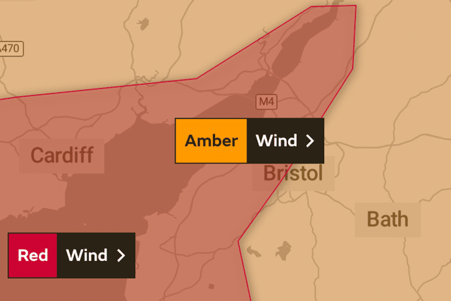
Hide AdHowever, that warning has now been upgraded to a red weather warning for half of the city of Bristol, which covers other South East regions of the UK such as Cardiff.


According to the Met Office, Bristol can expect “extremely strong winds”, with gales of around 65mph set to batter the city, causing a tidal surge which is a cause for concern for Bristol Port.
Bristol Port posted on Twitter: “Major storm to coincide with high spring tides.
“Potential for a Red Warning to be issued on February 17. Bristol Port is well prepared and will be implementing appropriate safety measures.”
Advertisement
Hide AdAdvertisement
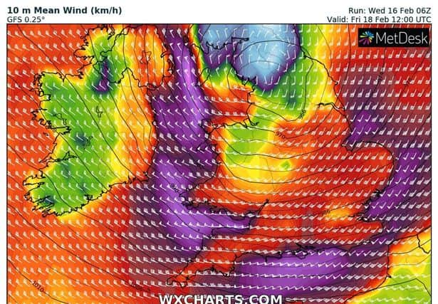
Hide AdStorm Eunice is due just days after Storm Dudley caused travel disruption and power cuts in parts of Scotland, Wales and Yorkshire - and Storm Eunice is expected to be even more disruptive and widespread.
A spokesperson for Bristol Airport said they were ‘keeping a close watch’ on the weather forecast.
They added: “We are advising all customers to check with their airlines for the latest flight information.”
When did Storm Eunice hit Bristol?
The Met Office’s red weather warning came into force in the western side of Bristol, including Avonmouth, from 7am on Friday morning, and lasts to midday.
Advertisement
Hide AdAdvertisement
Hide AdThe amber weather warning is set to last from 3am until 9pm on Friday evening, and the weather organisation has warned of the “significant disruption” that Storm Eunice will cause.
What does a red weather warning mean?
A red weather warning means that dangerous weather is expected and that people within the area should take action to keep themselves and others safe.
The Met Office states that danger to life is “very likely” and that substantial disruption will be caused to property, travel and energy supplies.
What are the Met Office warnings for Storm Eunice?
The Met Office have warned residents across South West England of the potential dangers caused by Storm Eunice.
Advertisement
Hide AdAdvertisement
Hide AdPeople in the more at-risk areas for flooding and winds are told to stay away from coastal areas, shoreline roads and paths, along with piers and promenades.
The Met Office warns of:
- Flying debris that could be a danger to life
- Damage to homes and buildings
- Roads, bridges and railway lines likely to close
- Good chance of power cuts
- Large waves and beach material causing disruption near the coast
- Falling branches and trees
What parts of Bristol are affected by Storm Eunice?


The amber weather warning covers the whole of Bristol and the South West, with coastal areas of the city issued with a red warning.
Storm Eunice is set to cause floods in and around the city, including surrounding areas such as the north coast of Somerset, Cornwall and Devon.
How is Storm Eunice set to unfold on Friday 17 February?
- 11am - pouring rain and and wind gusts rising to around 60mph
- 2pm - wind gusts still strong, at around 50mph, but rain stops and temperature increases to 7 C
- 5pm - gales decrease to around 45mph and temperatures drop to 4 C. Chance of rail.
- 8pm- wind gusts fall to around 20mph with a dry night ahead, feeling cold though.
The Met Office says that on Friday in Bristol, “Storm Eunice will bring very strong and damaging winds. Winds will give large waves around the coast too. Rain will clear to leave blustery showers, perhaps wintry over The Moors. Maximum temperature 10 °C.”
Advertisement
Hide AdAdvertisement
Hide AdAfter the weather warning ends in Bristol, miserable weather will continue on into the weekend.
Saturday and Sunday will see strong winds continue, along with heavy rain and even some sleet, with conditions becoming more calm on Monday.
Comment Guidelines
National World encourages reader discussion on our stories. User feedback, insights and back-and-forth exchanges add a rich layer of context to reporting. Please review our Community Guidelines before commenting.
