Thunderstorm warning Bristol: when will city get thunder and lightning - and Met Office weather forecast

and live on Freeview channel 276
People of Bristol have been rather lucky when it comes to the weather over the last week, with scorching hot temperatures leading to the city’s hottest day of the year.
Enjoying some time in the open air with friends and family, as well as all the various activities that Bristol has to offer, and heading out on spring walks - life has been blissful.
Advertisement
Hide AdAdvertisement
Hide AdHowever, weather experts are predicting all this to come to a crunching halt right as the summer season gets underway.
The Met Office has issued a yellow weather warning, so here is everything you need to know.
What is the weather warning and how long is it in place?
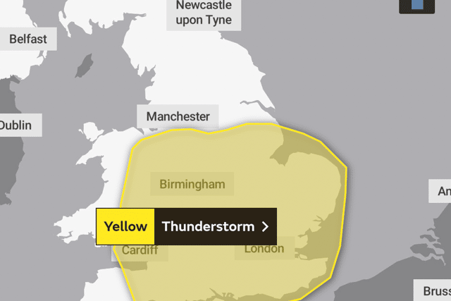

The yellow weather warning is for thunderstorms and it covers most of the South West of England and some of South Wales.
It is scheduled to be in place from 10 am to 11:59 pm - a day full of what experts warn are ‘thunderstorms and torrential downpours’.
What does a yellow weather warning mean?
Advertisement
Hide AdAdvertisement
Hide AdYellow warnings can be issued to clarify various weather conditions that will cause a low level impact and disruption.
A large majority of people will still be able to continue their normal everyday life under this warning, but there will be some that could be negatively affected.
These warnings can also be issued when the weather has a possibility of causing severe impacts to the majority of people, but the chances of such occurring is largely minimal.
What should I expect in Bristol?
The Met Office has issued a list of all the potential effects of the emerging thunderstorms that are set to arrive in Bristol. These include:
- There is a small chance that homes and businesses could be flooded quickly, with damage to some buildings from floodwater, lightning strikes, hail or strong winds
- There is a small chance of fast flowing or deep flood water causing danger to life
- Wherever a flooding or lightning strikes occur, there is a chance of delays and some cancellations to train and bus services
- Spray and sudden flooding could lead to difficult driving conditions, as well as some road closures
- Slight chance of power cuts and other services to homes and businesses could be lost
- There is a small chance that some communities could be cut off by flooded roads
What is the hourly weather forecast for Bristol on Thursday?
Advertisement
Hide AdAdvertisement
Hide AdThe Met Office has issued the following hourly forecast for Bristol during the hours of the yellow weather warning for thunderstorms on Thursday, 23 June 2022:
- 6 am to 11 am - sunny and dry with hot temperatures, highs of 24℃ which are expected at 11 am
- 12 pm to 3 pm - dry conditions, cloudy skies and warm temperatures, highs of 25℃ which are expected between 12 pm and 2 pm
- 4 pm - cloudy conditions, some rainfall with a 50% chance, highs of 24℃
- 5 pm - cloudy and dry conditions, highs of 23℃
- 6 pm to 9 pm - clouds in the sky, sunny intervals and milder temperatures, highs of 23℃ are expected at 6 pm, lows of 20℃ at 9 pm
- 10 pm to 11 pm - cloudy skies and dry with mild temperatures, highs of 19℃ are expected at 10 pm, 18℃ at 11 pm
What is the Met Office long range weather forecast?
Here is the longe range weather forecast from the Met Office for the rest of June and towards the start of July in the UK (Monday, 27 June to Wednesday, 6 July)
“Monday is likely to bring locally heavy showers that spread east through the day,” reads the Met Office statement.
“These will be heaviest and most frequent in the west, with the best chance of any dry and bright weather in the east.
Advertisement
Hide AdAdvertisement
Hide Ad“Winds remaining moderate for most, perhaps strong in coastal areas. For the middle of next week many will see sunny spells and showers, most frequently in the north and northwest, with the potential for some longer spells of rain.
“Further into the period, the north is expected to continue to be unsettled with showers and longer spells of rain.
“Whereas in the south, drier weather with only the occasional shower is more likely.
“Despite a slightly cooler start, temperatures returning to near normal for the second half of the period.”
Comment Guidelines
National World encourages reader discussion on our stories. User feedback, insights and back-and-forth exchanges add a rich layer of context to reporting. Please review our Community Guidelines before commenting.