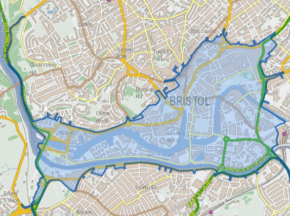
Bristol Clean Air Zone: Map for congestion charge and key road entrances


Bristol’s Clean Air Zone (CAZ) is scheduled to come into place on November 28. The city centre and some surrounding areas will be blanketed in the zone, designed to prevent most older, polluting vehicles from further descreasing the area’s air quality.
Daily charges will be handed out to vehicles which do not meet Bristol City Council’s criteria and the authority has said it is motorists’ responsibility to know when they have entered the zone and will be expected to pay a charge.
Advertisement
Hide AdAdvertisement
Hide AdSeveral main roads in and out of the city run through the CAZ with some residents complaining the zone will make it either impossible for them to get to and from work as well as personal and medical appointments. Others claim their businesses will be financially damaged by the daily charges, ranging from £9 for cars, taxis and vans to £100 for HGVs, coaches and buses.
There are signs for the zone on all roads on its boundary but here are the CAZ entry points to watch out for, stretching from Bedminster to Clifton to St Pauls to Totterdown:
Bridge Valley Road
The Bridge Valley Road section of the CAZ is the most-Northern point, connecting to Clifton Down. The road’s Avon Gorge entrance is also included in the CAZ.
The connecting Portway/Hotwell Road is included.
Clanage Road Roudabout, Winterstoke Underpass and Ashton Gate Underpass
South Bristol residents are likely to enter the CAZ from these three entry points which connect the city’s South to the Brunel Way and beyond.
Advertisement
Hide AdAdvertisement
Hide AdTurning right onto Ashton Road, the boundary is met once again at Southville’s Coronation Road.
East Street/Bedminster Bridge
Bedminster’s East Street bottlenecks into the CAZ boundary at the Bedminster bridge into and out of Redcliffe.
The bridge connects the busy commuter area and neighbourhood to the city’s centre and Temple Meads train station, which is based just outside of the zone.
Three Lamps Junction
The CAZ’s most-Easterly point, known locally as the Three Lamps Junction, includes the Wells Road and Bath Road intersection.
Newfoundland Way
Advertisement
Hide AdAdvertisement
Hide AdConnecting from the M32, Newfoundland Way takes drivers into the CAZ shortly before the Bond Street South turn, eventually leading on to the Bearpit.
Other entry points between Newfoundland Way and the Bridge Valley Road locations include Stokes Croft and St Michael’s Hill.
Comment Guidelines
National World encourages reader discussion on our stories. User feedback, insights and back-and-forth exchanges add a rich layer of context to reporting. Please review our Community Guidelines before commenting.
